Okutama Day Trip: Hiking the Tama River from Tokyo
Practical Guide to Walking Along the Tama River in Okutama

- +0 0
-

-


I have walked this part of Okutama several times around late spring or summer, and each time, a few small details change slightly: the light on the river, the pace of the water, the number of people sharing the path. The route itself stays familiar, and that familiarity is part of its appeal.
This time, I will focus on the section that follows the Tama River between Sawai Station and Okutama Station. It is an easy corridor where the landscape does most of the work: Paths stay close to the water, bridges arrive at regular intervals, and the walk unfolds in a natural sequence of gorgeous scenery, well-suited to an unhurried day.
Farther upstream than this would require longer and a different kind of planning, changing the character of the outing. Distance, timing, and return options start to shape decisions. This stretch keeps the experience grounded in a relaxed day trip from central Tokyo. The river also sets a quiet rhythm. Hikers move along the banks, anglers stand still for long stretches, and in warmer months, rafts pass through the gorge below.
What follows is not a prescribed route, but a way of reading the landscape as it unfolds along the Tama River, one bridge, bend, and pause at a time.
Easy Access by Train for a Convenient Day Trip
From central Tokyo, the journey is handled almost entirely by regular commuter lines, which is one of the main reasons this area works so well for a day trip. Most routes begin on the Chuo Line, heading west from major hubs such as Tokyo Station, Shinjuku, or Mitaka. Trains bound for Ome or further west are frequent, and even when a transfer is required, it is usually limited to a single change at Ome Station. From there, the Ome Line continues upstream along the Tama River, stopping at Sawai and terminating at Okutama.
Travel time typically falls in the 90–120 minute range, depending on departure point and connection timing. The ride gradually shifts from dense suburbs to wooded slopes and river valleys, an incredible sight, taking into account that we’re still well within the limits of Tokyo Prefecture. Importantly, this is not a special excursion line; regular IC cards work throughout, and there is no need for advance reservations.
For a relaxed outing, Sawai Station is an ideal place to step off the train and begin walking, with Okutama Station serving as an endpoint. Both stations sit directly on the river corridor discussed in this article, allowing the day to unfold on foot without backtracking or additional transport.
Day Trip Exploring Around Okutama
The following is not meant to be taken as a specific itinerary, as I want to encourage readers to explore at their own pace without following any particular order. As such, the spots mentioned below serve as points of reference along the way, rather than must-see landmarks. The start and end stations are the ones I have chosen for convenience due to their short distance to the riverside walking path, but that doesn’t mean you should follow the same order I did. For instance, Getting off at Okutama Station and walking on the opposite direction would work as well.
The path stays close to the Tama River, alternating between paved sections, compacted dirt, and short wooden walkways. Elevation changes are minimal, which keeps attention on the river rather than on footing or fatigue. I like thinking of this like a relaxed walk in the park, except that I’m surrounded by actual wilderness. Water is the constant reference point. In some stretches it runs wide and calm, reflecting the surrounding slopes; in others it narrows and picks up speed, cutting between exposed rock.
Sawai Station: Where the Walk Begins
Sawai Station (沢井駅) is just a small and functional station. Once outside the ticket gates, the Tama River is already close, so it’s a practical place to start. The paths leading toward the river are clear, and within minutes, the sound of water replaces that of passing trains.
Sawai is also well-positioned geographically. Starting here keeps the day focused on the most accessible section of the river corridor, where paths are well maintained and distances remain manageable. The route toward Mitake Gorge follows its curves closely, alternating between open views and shaded sections beneath trees. There is no formal trailhead announcement, no sign telling you that the walk has begun. It simply does, which is exactly how Sawai should function in a day like this.
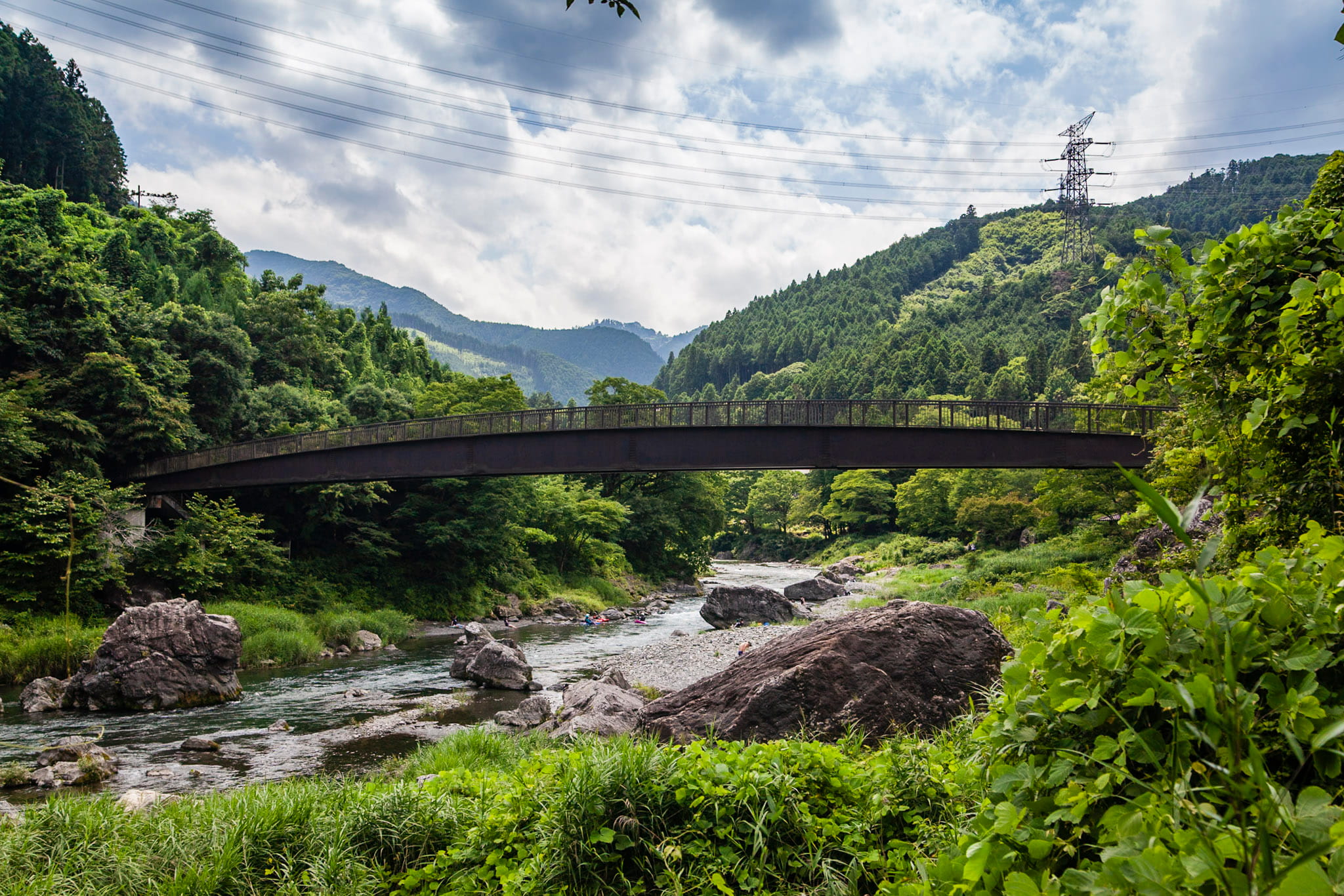
Unosehashi Bridge: A Quiet Crossing Above the Water


Unosehashi (鵜の瀬橋) sits at a natural pause point along the Tama River. It is not a landmark that announces itself from afar. Instead, it appears almost incidentally, spanning a narrower section of the river where the water accelerates and the banks pull closer together.
The bridge itself is modest in scale and purely functional, without dramatic height or architectural flourish.


The walking area around the bridge is wide enough to rest for a bit or set up a picnic spot if you like. Some shallow rapids around the area are suitable for leisure activities such as rafting, while being relatively calm for bathing.


A bit further upstream, you’ll find Emi, a quaint soba restaurant where I like to stop by when I’m in the area. The offering is simple and quite affordable for lunch for a quick stop, and the soba feels even more delicious when eating while enjoying the landscape by the window.
 Access Access |
15-min walk from Sawai Station |
|---|---|
 Business Hours Business Hours |
11 am–4 pm |
 Closed Closed |
Mon-Tue |
 Official Website Official Website |
http://kissaemi.yu-yake.com/ |
As a side note, I get it that if you’re in the area, you probably have the proper gear already, right? But let’s suppose you realize your shoes are not as reliable as you thought they were, you experience a mishap or maybe you’re just regretting not having a good pair of water shoes to walk freely inside the river (what happened to me); in such cases, I’d like to recommend Maunga (マウンガ), a nearby shop selling second hand mountaneering goods, quite close to Mitake Station.
| Access |
1-min walk from Mitake Station |
|---|---|
| Business Hours |
9 am–7 pm |
| Official Website |
http://www.maunga.jp/ |
Mitake Gorge


Over a distance of roughly four kilometers, the river meanders through a carved valley forming Mitake Gorge (御岳渓谷), an area that feels larger and more active than the gentler stretch just downstream. Mitake Bridge (御岳橋) is considerably larger, and the contrast with the scenery creates an interesting effect. The riverside trails are relatively flat, mostly well-maintained, and easy to follow. They are part of a larger loop that links local points of interest such as art museums, a sake brewery garden, and small temples, so you can stop for a little detour if you feel like it.
Unlike the broader, quieter reaches near Sawai, Mitake Gorge carries a bit more energy. Less difficult than true white-water sections, this stretch still hosts canoeing and other river activities in season. From the walking path, you’ll sometimes see people paddling, negotiating mild rapids, or floating past boulder clusters. That activity gives the gorge an approachable yet dynamic feel for those who prefer to stay on land.
In the vicinity lies Mt. Mitake; check out my recent guide if you want to explore further!
Jinrobashi Bridge


Jinrobashi (神路橋) is a small suspension footbridge spanning the river near the Mitake area, linking trails on opposite banks and giving pedestrians a direct way across a section of the valley. Sitting roughly 14 metres above the water, it gives enough perspective to appreciate the surroundings.
Locals and regular hikers sometimes use Shinrobashi as a connector between trails on either side of the river or as a way to access less-traveled paths that climb toward the hills.
Okutama Ohashi Bridge
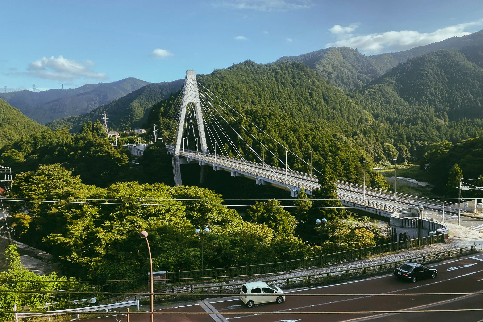
Okutama Ohashi (奥多摩大橋) is easy to spot from afar. Its sheer size unlike the smaller pedestrian crossings upstream, clean and sharp lines, and white color sit in stark contrast to the surrounding greenery, which I found gave it a clear presence across the river. Built in the 1990s near Kawai Station to handle cars and buses, it has the scale and feel of modern infrastructure, signaling that we’re nearing Okutama town.
Shiromaru Dam and Lake
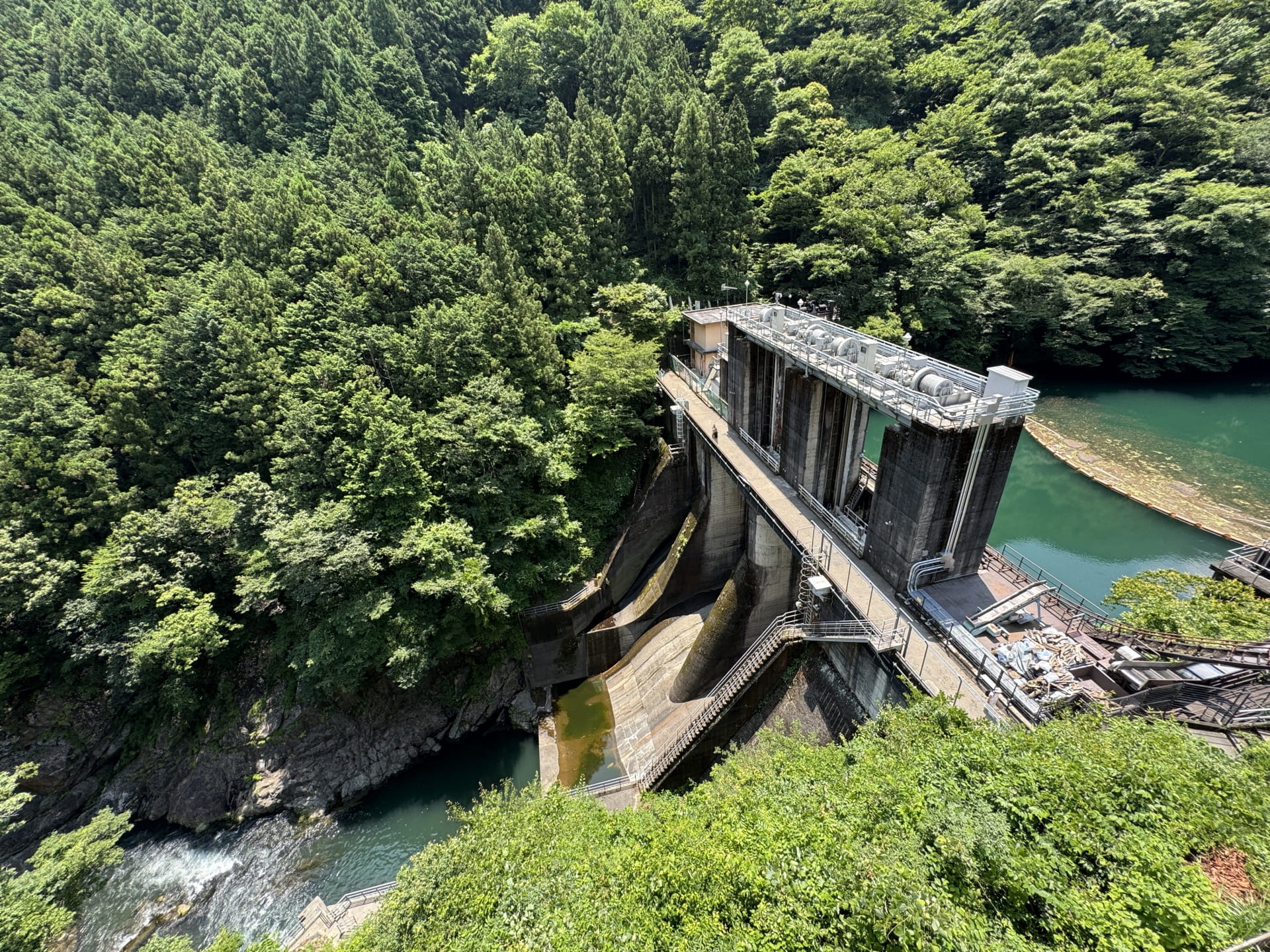
A short distance upstream from the core riverside walk corridor around Okutama, Shiromaru Dam (白丸ダム) is a distinct pivot point in the Tama River’s broader landscape. This concrete structure impounds a reservoir known locally as Lake Shiromaru (白丸湖), which contrasts sharply with the narrow gorges downstream. The dam was completed in 1962–63 as a power‑generation facility, feeding water to the Shiromaru Power Plant and the Tamagawa Third Power Plant, and it remains an active part of the region’s hydrology.
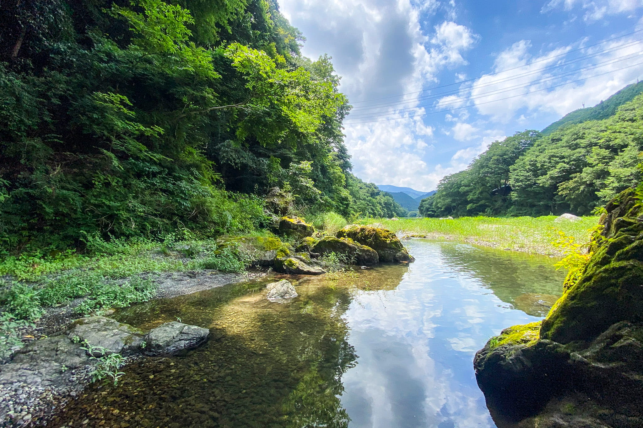
Lake Shiromaru itself sits at the top of a gently broadening valley. Its water often takes on an emerald‑green hue, especially on calm days, a result of minerals in the riverbed interacting with light, an effect that many local photographers and hikers remark on. The visit involves a detour from the riverside walking corridor but the scenery is worth it if you can spare the extra time.
Okutama Station Area


Okutama Station (奥多摩駅) is the western terminus of the JR Ome Line. The station sits a short walk from the river and from the Hikawa Gorge paths, making it a natural place to finish without backtracking. The valley is a convergence zone where the Nippara River meets the Tama River just downstream from the station, forming a distinct riverbed area characterized by expanses of gravel and sand, slower water channels, and pockets that are used by locals for fishing and seasonal riverplay. The broader, calmer riverbed contrasts with the tighter corridor of Mitake Gorge upstream.
Within this area, trails are more interconnected than earlier on the riverside walk. Footpaths branch toward several popular local spots, and small suspension bridges appear that link different sections of the network. These crossings are part of the Hikawa Valley (氷川渓谷) walking routes, which are well-maintained loops that circle around scenic points near Okutama Station and the river junction.


Unlike the tighter canyon feel upstream, the terrain here involves a gentle mix of hills, riverbanks, and gravel river flats. On a warm day, you might see people spreading picnic blankets or wading briefly, as wide, shallow currents and expansive banks make this possible without venturing into intense whitewater.
There are several interesting viewpoints, such as Hikawa Kobashi (氷川小橋). Narrow, lightly built, and slightly flexible underfoot, this bridge spans the Tama River near the confluence with the Nippara River, just upstream of Okutama Station and connecting walking paths within the gorge. Nearby sits Showa Bridge (昭和橋), a striking steel arch red bridge carrying local traffic while also serving as a popular pedestrian viewpoint.
Optional Highlight: River Adventures on the Tama
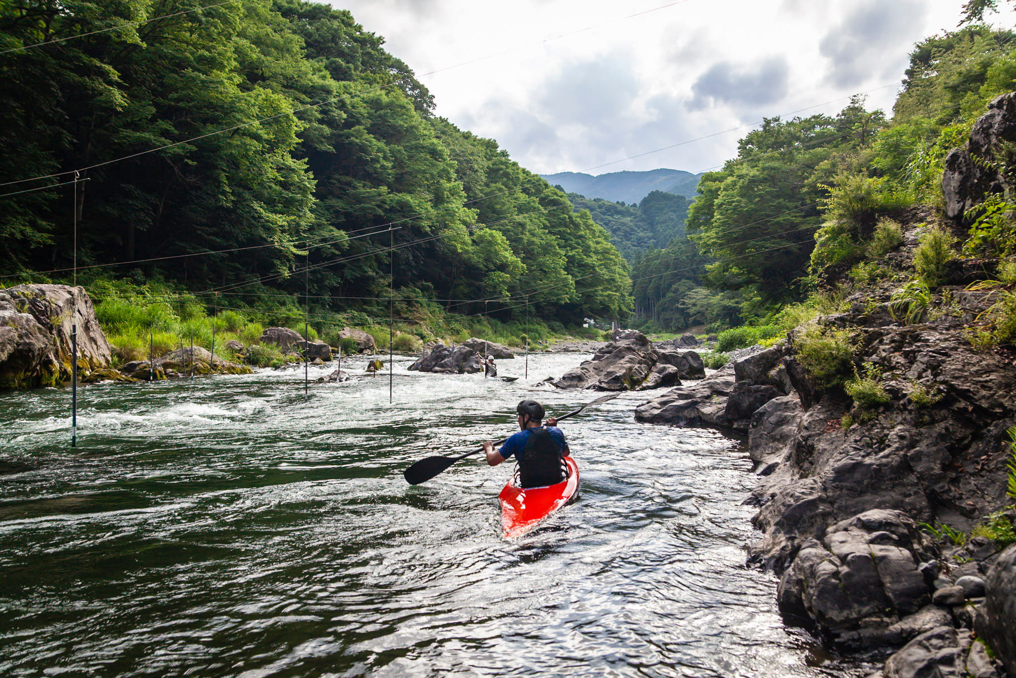
Okutama’s river is one of the nearest places to Tokyo where small rapids and clear water make water sports accessible, so walking along the Tama River between Sawai and Mitake Gorge, rafting is impossible to miss. In warmer months, rafts regularly pass through this section of the river, guided by instructors and carrying small groups who are clearly here for a different way of engaging with the landscape.
What’s available
Okutama is one of the most established rafting areas within easy reach of Tokyo. Several professional operators run guided rafting tours on the Tama River, mainly from spring to early autumn. These companies cater primarily to beginners and casual participants rather than experienced white-water specialists.
Tours are fully guided and usually include:
- Rafts, paddles, helmets, and life jackets
- Safety briefings before entering the water
- Group-based navigation led by certified guides
Some operators also offer related activities such as packrafting or canyoning, but standard rafting remains the most visible and accessible option in this area.
Typical Experience


Rafting on the Tama River in Okutama is active but controlled. The river alternates between short stretches of mild rapids and calmer water, allowing guides to maintain a steady pace without constant technical difficulty. Participants paddle together through faster sections, then slow down in wider areas where the river opens up.
A typical outing lasts around two to three hours, including preparation and instruction. No prior rafting experience is required, and swimming ability is generally sufficient at a basic level. The focus is on shared movement and interaction with the river rather than endurance or skill progression.
From the trails above, hikers often see rafts pause near bends or rock clusters before moving on, which mirrors the rhythm of the river itself.
Some local operators with English websites
- Crusoe — guides rafting tours on the Tama, usually in the April–October season, with options for families and groups, plus extras like photos and sometimes BBQ afterwards.
- Bigsmile — local operator offering white-water rafting tours on various parts of the Tama.
- Canyons and Grandex Okutama also run guided river activities, including rafting, packrafting, and related water tours.
Practical Tips for Walking Near Tama River
If you ask me, this riverside walk is best treated as a flexible half-day outing, easily adjusted to pace, weather, and energy levels. I did the entire route once, and then on subsequent visits, I’ve focused on smaller sections at a time. The route between Sawai Station and Okutama Station stays close to the Tama River throughout, with frequent access points back to roads or stations if plans change.
Timing and Difficulty
- Allow 3–5 hours, depending on detours, breaks, and how much time you spend around the river.
- The terrain is mostly flat or gently undulating, with well-maintained paths and occasional road sections.
- No technical hiking skills are required, but good walking shoes are recommended, especially after rain.
Seasonal Considerations
- Spring and autumn are ideal for comfortable temperatures and river views.
- Summer brings heat but also livelier river activity; shade is intermittent, so carry water.
- After heavy rainfall, some riverside paths may be muddy or partially submerged.
Food, Water, and Facilities
- Vending machines are scattered but not constant; stock up near stations.
- Cafés and small eateries cluster closer to Okutama Station, making it a natural endpoint for lunch or an early dinner.
- Public toilets are available near major stations and some trail access points.
Taken together, this combination of easy access, adaptable walking, and optional river activities is the reason why I find Okutama such a reliable destination for a day trip from central Tokyo: outdoorsy without being demanding, and varied without feeling rushed. Trains run frequently, the paths stay close to the river, and there are multiple points where you can shorten or extend the walk without committing to a full hike.
For a one-day escape that does not require advance planning or special equipment, this part of Okutama consistently delivers. It is well suited to repeat visits, different seasons, and different walking speeds — a practical, low-stress way to spend a day outside Tokyo.
Read more from my recent travel stories and guides:


For more information about things to do around Western Tokyo, check the articles below!


Written by
Photographer, journalist, and avid urban cyclist, making sense of Japan since 2017. I was born in Caracas and lived for 14 years in Barcelona before moving to Tokyo. Currently working towards my goal of visiting every prefecture in Japan, I hope to share with readers the everlasting joy of discovery and the neverending urge to keep exploring.
- +0 0
-
-